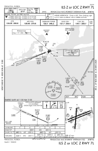
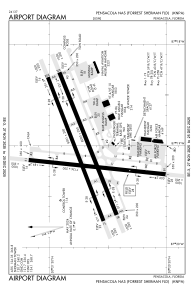


KNPA - Pensacola Nas (Forrest Sherman Fld)
Located in Pensacola, United States
ICAO - NPA, IATA -
Data provided by AirmateGeneral information
Coordinates: N30°21'12" W87°19'5"
Elevation is 28 feet MSL.
Magnetic variation is -01° East View others Airports in Florida
Operational data
Special qualification required
Current time UTC:
Current local time:
Weather
METAR: KNPA 090856Z AUTO 20011G20KT 10SM SCT014 SCT021 BKN040 28/24 A2980 RMK AO2 SLP093 T02830239 55002 $
TAF: TAF KNPA 0907/1007 18010KT 9999 BKN012 BKN020 QNH2982INS FM091600 18012KT 6000 SHRA VCTS SCT015CB BKN025 QNH2983INS FM092100 22013G23KT 9999 BKN015 BKN030 QNH2977INS AUTOMATED SENSOR METWATCH 0907 TIL 0911 TX32/0918Z TN27/0912Z FN00273
Communications frequencies: [VIEW]
Runways:
| RWY identifier | QFU | Length (ft) | Width (ft) | Surface | LDA (ft) |
| 01 | 0° | 7136 | 200 | ASPH | |
| 19 | 0° | 7136 | 200 | ASPH | |
| 07L | 0° | 8001 | 200 | ASPH | |
| 25R | 0° | 8001 | 200 | ASPH | |
| 07R | 0° | 8000 | 200 | ASPH | |
| 25L | 0° | 8000 | 200 | ASPH |
Airport contact information
Address: Pensacola United States