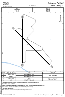


KNGW - Cabaniss Fld Nolf
Located in Corpus Christi, United States
ICAO - NGW, IATA -
Data provided by AirmateGeneral information
Coordinates: N27°42'9" W97°26'20"
Elevation is 31 feet MSL.
Magnetic variation is 05° East View others Airports in Texas
Operational data
Special qualification required
Current time UTC:
Current local time:
Weather at : KCRP - Corpus Christi Intl ( 10 km )
METAR: KCRP 091051Z 15008KT 6SM BR FEW010 OVC015 27/26 A2962 RMK AO2 SLP028 T02720256
TAF: KCRP 091130Z 0912/1012 12008KT 6SM BR FEW010 OVC015 TEMPO 0912/0913 4SM BR BKN007 FM091600 14007KT 5SM HZ BKN010 OVC020 FM091700 10011KT P6SM BKN250 FM100800 VRB06KT 5SM HZ BR BKN018
Communications frequencies: [VIEW]
Runways:
| RWY identifier | QFU | Length (ft) | Width (ft) | Surface | LDA (ft) |
| 13 | 135° | 4994 | 150 | ASPH | |
| 31 | 315° | 4994 | 150 | ASPH | |
| 18 | 180° | 4496 | 150 | OTHER | |
| 36 | 0° | 4496 | 150 | OTHER |
Airport contact information
Address: Corpus Christi United States