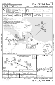
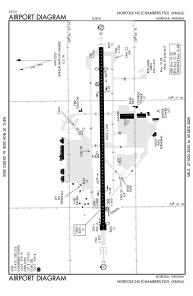


KNGU - Norfolk Ns (Chambers Fld)
Located in Norfolk, United States
ICAO - NGU, IATA -
Data provided by AirmateGeneral information
Coordinates: N36°56'15" W76°17'21"
Elevation is 14 feet MSL.
Magnetic variation is -10° East View others Airports in Virginia
Operational data
Special qualification required
Current time UTC:
Current local time:
Weather
METAR: KNGU 091859Z 28003KT 10SM SCT060 BKN110 BKN250 28/18 A2964 RMK AO2 SLP037 T02780178
TAF: TAF COR KNGU 0915/1015 25010KT 9999 VCSH SCT030 BKN100 OVC250 QNH2963INS TEMPO 0915/0920 6000 -SHRA BR BKN020 OVC090 BECMG 0920/0922 26012G20KT 8000 -SHRA VCTS SCT040CB BKN100 BKN250 QNH2956INS TEMPO 0922/1004 VRB20G35KT 1600 TSRA BR BKN020CB OVC090 BECMG 1004/1006 29006KT 6000 BR VCSH BKN007 BKN015 QNH2952INS TEMPO 1006/1012 3200 BR OVC002 TX29/0920Z TN21/0911Z FN20075
Communications frequencies: [VIEW]
Runways:
| RWY identifier | QFU | Length (ft) | Width (ft) | Surface | LDA (ft) |
| 10 | 90° | 8370 | 200 | ASPH | 8071 |
| 28 | 270° | 8370 | 200 | ASPH | 7375 |
Airport contact information
Address: Norfolk United States