


KNDY - Dahlgren Nsf
Located in Dahlgren, United States
ICAO - NDY, IATA - DGN
Data provided by AirmateGeneral information
Coordinates: N38°19'58" W77°2'13"
Elevation is 18 feet MSL.
Magnetic variation is -09° East View others Airports in Virginia
Operational data
Special qualification required
Current time UTC:
Current local time:
Weather at : KNYG - Quantico Mcaf (Turner Fld) ( 30 km )
METAR: KNYG 090456Z AUTO 29006KT 7SM CLR 21/18 A2971 RMK AO2 SLP062 T02060178 403170206 $
TAF: TAF KNYG 0903/1003 26012KT 9999 SKC QNH2968INS TEMPO 0909/0915 VRB06KT -SHRA OVC050 OVC150 FM091500 VRB15KT 8000 -TSRA BR OVC010CB OVC030 QNH2957INS T25/0919Z T17/1003Z
Communications frequencies: [VIEW]
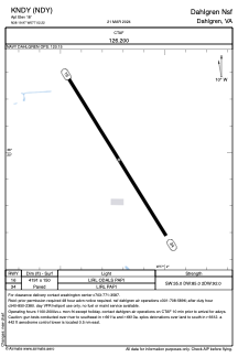
Runways:
| RWY identifier | QFU | Length (ft) | Width (ft) | Surface | LDA (ft) |
| 16 | 148° | 4191 | 150 | ASPH | |
| 34 | 328° | 4191 | 150 | ASPH |
Airport contact information
Address: Dahlgren United States