


KNBG - New Orleans Nas Jrb (Alvin Callender Fld)
Located in New Orleans, United States
ICAO - NBG, IATA - NBG
Data provided by AirmateGeneral information
Coordinates: N29°49'38" W90°1'36"
Elevation is 2 feet MSL.
Magnetic variation is 00° East View others Airports in Louisiana
Operational data
Special qualification required
Current time UTC:
Current local time:
Weather
TAF: TAF KNBG 0907/1007 19010G20KT 9999 SCT020 BKN030 BKN250 QNH2971INS BECMG 0914/0916 17008KT 9999 VCSH SCT020 BKN060 BKN250 QNH2972INS BECMG 1000/1002 18006KT 9999 NSW SCT030 BKN050 BKN250 QNH2974INS TX32/0919Z TN25/0910Z FN00273
Communications frequencies: [VIEW]
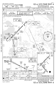
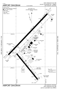
Runways:
| RWY identifier | QFU | Length (ft) | Width (ft) | Surface | LDA (ft) |
| 04 | 44° | 10000 | 200 | OTHER | |
| 22 | 224° | 10000 | 200 | OTHER | |
| 14 | 141° | 6000 | 200 | OTHER | |
| 32 | 321° | 6000 | 200 | OTHER |
Airport contact information
Address: New Orleans United States