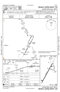
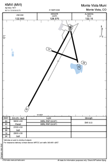


KMVI - Monte Vista Muni
Located in Monte Vista, United States
ICAO - MVI, IATA -
Data provided by AirmateGeneral information
Coordinates: N37°31'43" W106°2'45"
Elevation is 7611 feet MSL.
Magnetic variation is 08° East View others Airports in Colorado
Operational data
Special qualification required
Current time UTC:
Current local time:
Weather at : KALS - San Luis Valley Rgnl/Bergman Fld ( 19 km )
METAR: KALS 082252Z AUTO VRB04KT 10SM CLR 13/M11 A2981 RMK AO2 SLP049 T01331111
TAF: KALS 082048Z 0821/0918 08009KT P6SM FEW200 FM090000 03008KT P6SM FEW100 SCT200 FM090600 VRB06KT P6SM SCT100 BKN200 FM091600 12012KT P6SM SCT040 BKN080
Communications frequencies: [VIEW]
Runways:
| RWY identifier | QFU | Length (ft) | Width (ft) | Surface | LDA (ft) |
| 02 | 29° | 5902 | 60 | ASPH | |
| 20 | 209° | 5902 | 60 | ASPH | |
| 10 | 111° | 2100 | 50 | EARTH | |
| 28 | 291° | 2100 | 50 | EARTH | |
| 16 | 167° | 2300 | 30 | EARTH | |
| 34 | 347° | 2300 | 30 | EARTH |
Airport contact information
Address: Monte Vista United States