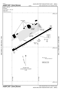


KMUI - Muir Ahp (Fort Indiantown Gap)
Located in Fort Indiantown Gap (Annville), United States
ICAO - MUI, IATA -
Data provided by AirmateGeneral information
Coordinates: N40°26'7" W76°34'7"
Elevation is 487 feet MSL.
Magnetic variation is -10° East View others Airports in Pennsylvania
Operational data
Special qualification required
Current time UTC:
Current local time:
Weather
TAF: TAF KMUI 171900Z 1719/1901 VRB06KT 9999 FEW020 BKN025 OVC040 QNH2995INS BECMG 1802/1803 VRB06KT 4800 -RA SCT005 OVC010 QNH2995INS BECMG 1808/1809 VRB06KT 8000 -SHRA OVC005 QNH2994INS BECMG 1819/1820 VRB06KT 9999 NSW SCT005 OVC010 QNH2996INS TX20/1720Z TN14/1812Z
Communications frequencies: [VIEW]
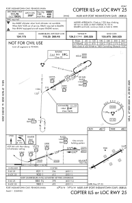
Runways:
| RWY identifier | QFU | Length (ft) | Width (ft) | Surface | LDA (ft) |
| 07 | 60° | 3967 | 100 | ASP | |
| 25 | 240° | 3967 | 100 | ASP |
Airport contact information
Address: Fort Indiantown Gap (Annville) United States