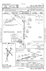
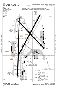


KMSN - Dane County Rgnl/Truax Fld
Located in Madison, United States
ICAO - MSN, IATA - MSN
Data provided by AirmateGeneral information
Coordinates: N43°8'24" W89°20'15"
Elevation is 886 feet MSL.
Magnetic variation is -03° East View others Airports in Wisconsin
Operational data
Special qualification required
Current time UTC:
Current local time:
Weather
METAR: KMSN 201653Z 06007KT 10SM SCT028 BKN110 OVC200 18/14 A2984 RMK AO2 RAB33E45 SLP103 P0000 T01830144 $
TAF: KMSN 201414Z 2014/2112 13006KT P6SM FEW060 BKN100 TEMPO 2014/2016 3SM -TSRA OVC040CB FM201600 20013G21KT P6SM SCT035 BKN080 FM201700 20010G20KT 4SM -TSRA BKN035CB FM202200 23008KT P6SM BKN021 FM210200 VRB04KT P6SM SCT110
Communications frequencies: [VIEW]
Runways:
| RWY identifier | QFU | Length (ft) | Width (ft) | Surface | LDA (ft) |
| 03 | 29° | 7200 | 150 | CONC | 6770 |
| 21 | 209° | 7200 | 150 | CONC | 7015 |
| 14 | 136° | 5846 | 150 | CONC | 5369 |
| 32 | 316° | 5846 | 150 | CONC | 5846 |
| 18 | 182° | 9006 | 150 | CONC | 8606 |
| 36 | 2° | 9006 | 150 | CONC | 8006 |
Airport contact information
Address: Madison United States
