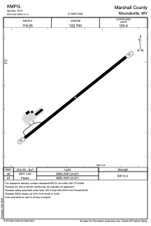


KMPG - Marshall County
Located in Moundsville, United States
ICAO - MPG, IATA -
Data provided by AirmateGeneral information
Coordinates: N39°52'51" W80°44'9"
Elevation is 1214 feet MSL.
Magnetic variation is -08° East View others Airports in West Virginia
Operational data
Special qualification required
Current time UTC:
Current local time:
Weather at : KHLG - Wheeling Ohio County ( 34 km )
METAR: KHLG 090553Z AUTO 00000KT 10SM FEW070 18/10 A2974 RMK AO2 SLP066 T01780100 10228 20167 58007
TAF: KHLG 090538Z 0906/1006 00000KT P6SM OVC200 FM091200 06007KT P6SM -SHRA BKN035 FM091600 12008KT 6SM -SHRA BKN025 FM092000 20011KT 5SM -SHRA BR VCTS BKN015CB FM100000 VRB05KT 6SM BR VCSH BKN012
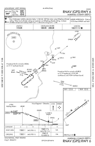
Communications frequencies: [VIEW]
Runways:
| RWY identifier | QFU | Length (ft) | Width (ft) | Surface | LDA (ft) |
| 06 | 52° | 3301 | 60 | ASPH | |
| 24 | 232° | 3301 | 60 | ASPH |
Airport contact information
Address: Moundsville United States