


KMLU - Monroe Rgnl
Located in Monroe, United States
ICAO - MLU, IATA - MLU
Data provided by AirmateGeneral information
Coordinates: N32°30'38" W92°2'10"
Elevation is 79 feet MSL.
Magnetic variation is 03° East View others Airports in Louisiana
Operational data
Special qualification required
Current time UTC:
Current local time:
Weather
METAR: KMLU 090353Z AUTO 20004KT 10SM CLR 26/22 A2972 RMK AO2 SLP061 T02560222
TAF: KMLU 082335Z 0900/0924 19012G18KT P6SM SCT045 BKN250 FM090600 20008KT P6SM SCT015 BKN250 FM090800 21007KT P6SM BKN015 FM091600 VRB04KT P6SM BKN020 FM091900 06005KT P6SM SCT035
Communications frequencies: [VIEW]
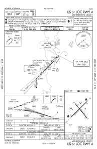
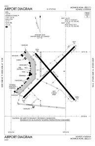
Runways:
| RWY identifier | QFU | Length (ft) | Width (ft) | Surface | LDA (ft) |
| 04 | 45° | 7504 | 150 | ASPH | 7504 |
| 22 | 225° | 7504 | 150 | ASPH | 7504 |
| 14 | 140° | 6301 | 150 | ASPH | 6301 |
| 32 | 320° | 6301 | 150 | ASPH | 6301 |
Airport contact information
Address: Monroe United States