


KMLS - Frank Wiley Fld
Located in Miles City, United States
ICAO - MLS, IATA - MLS
Data provided by AirmateGeneral information
Coordinates: N46°25'37" W105°53'18"
Elevation is 2634 feet MSL.
Magnetic variation is 09° East View others Airports in Montana
Operational data
Special qualification required
Current time UTC:
Current local time:
Weather
METAR: KMLS 081453Z AUTO 04016KT 9SM BKN015 BKN023 OVC031 09/09 A2962 RMK AO2 RAB24E38 SLP036 P0000 60002 T00940089 53034
TAF: KMLS 081229Z 0812/0912 30015KT 5SM -RA BR SCT007 OVC012 FM081600 36016KT 6SM -RA BR SCT007 OVC012 FM082100 02016KT P6SM VCSH SCT015 BKN025 OVC040 FM090300 02009KT P6SM SCT025 BKN050
Communications frequencies: [VIEW]
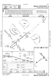
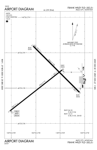
Runways:
| RWY identifier | QFU | Length (ft) | Width (ft) | Surface | LDA (ft) |
| 04 | 52° | 5764 | 75 | ASPH | 5764 |
| 22 | 232° | 5764 | 75 | ASPH | 5764 |
| 13 | 135° | 5624 | 100 | ASPH | 5624 |
| 31 | 315° | 5624 | 100 | ASPH | 5624 |
Airport contact information
Address: Miles City United States