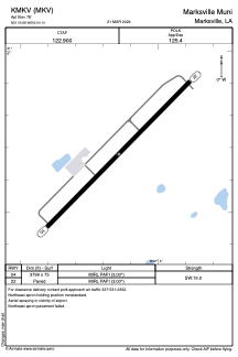


KMKV - Marksville Muni
Located in Marksville, United States
ICAO - MKV, IATA -
Data provided by AirmateGeneral information
Coordinates: N31°5'41" W92°4'9"
Elevation is 78 feet MSL.
Magnetic variation is 02° East View others Airports in Louisiana
Operational data
Special qualification required
Current time UTC:
Current local time:
Weather at : KESF - Esler Rgnl ( 40 km )
METAR: KESF 091453Z AUTO 22004KT 2 1/2SM HZ OVC017 28/24 A2976 RMK AO2 SLP077 T02780244 52004
Communications frequencies: [VIEW]
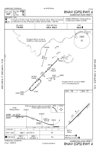
Runways:
| RWY identifier | QFU | Length (ft) | Width (ft) | Surface | LDA (ft) |
| 04 | 45° | 3799 | 75 | ASPH | |
| 22 | 225° | 3799 | 75 | ASPH |
Airport contact information
Address: Marksville United States