


KMKL - Mc Kellar-Sipes Rgnl
Located in Jackson, United States
ICAO - MKL, IATA - MKL
Data provided by AirmateGeneral information
Coordinates: N35°35'60" W88°54'56"
Elevation is 433 feet MSL.
Magnetic variation is -01° East View others Airports in Tennessee
Operational data
Special qualification required
Current time UTC:
Current local time:
Weather
TAF: KMKL 080520Z 0806/0906 20009KT P6SM VCSH SCT030 BKN045 FM081100 20009KT P6SM SCT012 BKN022 FM081500 20012G19KT P6SM BKN025 FM082200 21011KT P6SM VCTS SCT035CB BKN050 PROB30 0904/0906 23013G18KT 3SM -TSRA BKN025CB
Communications frequencies: [VIEW]
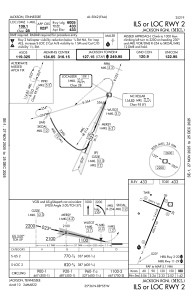
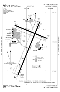
Runways:
| RWY identifier | QFU | Length (ft) | Width (ft) | Surface | LDA (ft) |
| 02 | 22° | 6005 | 150 | ASPH | |
| 20 | 202° | 6005 | 150 | ASPH | |
| 11 | 112° | 3539 | 100 | ASPH | |
| 29 | 292° | 3539 | 100 | ASPH |
Airport contact information
Address: Jackson United States