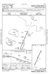
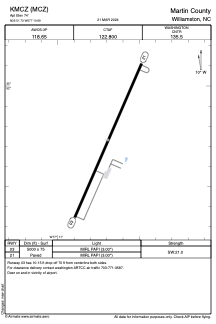


KMCZ - Martin County
Located in Williamston, United States
ICAO - MCZ, IATA -
Data provided by AirmateGeneral information
Coordinates: N35°51'44" W77°10'42"
Elevation is 74 feet MSL.
Magnetic variation is -09° East View others Airports in North Carolina
Operational data
Special qualification required
Current time UTC:
Current local time:
Weather at : KPGV - Pitt-Greenville ( 31 km )
METAR: KPGV 180245Z AUTO 15006KT 10SM OVC013 20/20 A2996 RMK AO2
TAF: KPGV 172322Z 1800/1824 14008KT P6SM VCSH BKN025 BKN040 FM180200 14008KT P6SM VCSH BKN025 FM181000 15008KT P6SM SHRA BKN006 FM181700 VRB06KT P6SM SHRA VCTS SCT008 BKN015CB AMD LTD TO CLD VIS AND WIND
Communications frequencies: [VIEW]
Runways:
| RWY identifier | QFU | Length (ft) | Width (ft) | Surface | LDA (ft) |
| 03 | 24° | 5000 | 75 | ASPH | |
| 21 | 204° | 5000 | 75 | ASPH |
Airport contact information
Address: Williamston United States