


KMCK - Mc Cook Ben Nelson Rgnl
Located in Mc Cook, United States
ICAO - MCK, IATA - MCK
Data provided by AirmateGeneral information
Coordinates: N40°12'23" W100°35'32"
Elevation is 2582 feet MSL.
Magnetic variation is 08° East View others Airports in Nebraska
Operational data
Special qualification required
Current time UTC:
Current local time:
Weather
METAR: KMCK 081553Z AUTO 31018KT 10SM CLR 17/M01 A2965 RMK AO2 PK WND 33028/1534 SLP024 T01721011
TAF: KMCK 081120Z 0812/0912 27011KT P6SM FEW250 FM081400 29016G24KT P6SM SKC FM090100 34009KT P6SM FEW250
Communications frequencies: [VIEW]
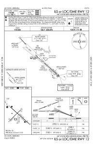
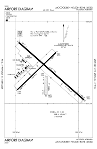
Runways:
| RWY identifier | QFU | Length (ft) | Width (ft) | Surface | LDA (ft) |
| 04 | 46° | 4000 | 75 | CONC | 4000 |
| 22 | 226° | 4000 | 75 | CONC | 4000 |
| 12 | 131° | 6450 | 100 | CONC | 5698 |
| 30 | 311° | 6450 | 100 | CONC | 5698 |
| 17 | 181° | 1330 | 160 | GRASS | |
| 35 | 1° | 1330 | 160 | GRASS |
Airport contact information
Address: Mc Cook United States

