


KMBS - Mbs Intl
Located in Saginaw, United States
ICAO - MBS, IATA - MBS
Data provided by AirmateGeneral information
Coordinates: N43°31'59" W84°4'47"
Elevation is 668 feet MSL.
Magnetic variation is -07° East View others Airports in Michigan
Operational data
Special qualification required
Current time UTC:
Current local time:
Weather
METAR: KMBS 081753Z 31017KT 10SM SCT044 21/11 A2969 RMK AO2 PK WND 27028/1702 SLP054 T02110111 10211 20139 53015
TAF: KMBS 081720Z 0818/0918 28015G28KT P6SM OVC045 FM082100 34010KT P6SM OVC035 FM090000 06010KT P6SM SCT040 BKN250 FM091500 05010KT 3SM -RA OVC015
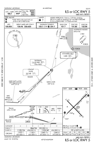
Communications frequencies: [VIEW]
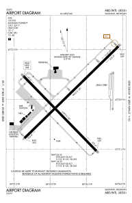
Runways:
| RWY identifier | QFU | Length (ft) | Width (ft) | Surface | LDA (ft) |
| 05 | 46° | 8002 | 150 | ASPH | 8002 |
| 23 | 226° | 8002 | 150 | ASPH | 8002 |
| 14 | 136° | 6399 | 150 | ASPH | 6399 |
| 32 | 316° | 6399 | 150 | ASPH | 6399 |
Airport contact information
Address: Saginaw United States