


KLXV - Lake County
Located in Leadville, United States
ICAO - LXV, IATA - LXV
Data provided by AirmateGeneral information
Coordinates: N39°13'10" W106°18'59"
Elevation is 9933 feet MSL.
Magnetic variation is 09° East View others Airports in Colorado
Operational data
Special qualification required
Current time UTC:
Current local time:
Weather
METAR: KLXV 081153Z AUTO VRB03KT 10SM BKN027 OVC035 M10/M13 A2982 RMK AO2 SLP068 60002 70057 T11001133 11061 21117 53003
Communications frequencies: [VIEW]
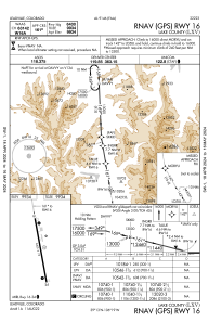
Runways:
| RWY identifier | QFU | Length (ft) | Width (ft) | Surface | LDA (ft) |
| 16 | 170° | 6400 | 75 | ASPH | |
| 34 | 350° | 6400 | 75 | ASPH | |
| H1 | 0° | 0 | 0 | UNK |
Airport contact information
Address: Leadville United States