


KLWB - Greenbrier Valley
Located in Lewisburg, United States
ICAO - LWB, IATA - LWB
Data provided by AirmateGeneral information
Coordinates: N37°51'30" W80°23'58"
Elevation is 2301 feet MSL.
Magnetic variation is -08° East View others Airports in West Virginia
Operational data
Special qualification required
Current time UTC:
Current local time:
Weather
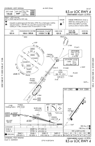
METAR: KLWB 091310Z 22007KT 10SM SCT005 OVC023 16/16 A2980
TAF: KLWB 091304Z 0913/1012 00000KT 5SM BR BKN003 FM091330 VRB04KT P6SM SCT100 FM091600 24006KT P6SM SCT070 FM091900 27010KT P6SM VCSH BKN050 FM100400 27007KT P6SM OVC025
Communications frequencies: [VIEW]
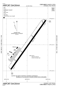
Runways:
| RWY identifier | QFU | Length (ft) | Width (ft) | Surface | LDA (ft) |
| 04 | 35° | 7003 | 150 | ASPH | 7003 |
| 22 | 215° | 7003 | 150 | ASPH | 7003 |
Airport contact information
Address: Lewisburg United States
