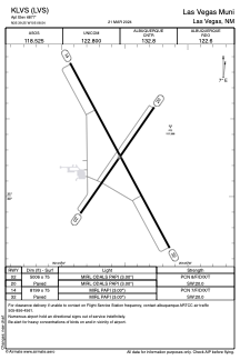


KLVS - Las Vegas Muni
Located in Las Vegas, United States
ICAO - LVS, IATA - LVS
Data provided by AirmateGeneral information
Coordinates: N35°39'15" W105°8'33"
Elevation is 6877 feet MSL.
Magnetic variation is 13° East View others Airports in New Mexico
Operational data
Special qualification required
Current time UTC:
Current local time:
Weather
METAR: KLVS 081353Z AUTO 21009KT 10SM CLR 12/M09 A2980 RMK AO2 SLP000 T01171094
TAF: KLVS 081122Z 0812/0912 21011KT P6SM SKC FM081500 26015G25KT P6SM SKC FM081800 25028G38KT P6SM SKC FM090200 28009KT P6SM BKN120 FM090600 04009KT P6SM BKN120
Communications frequencies: [VIEW]
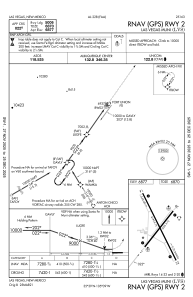
Runways:
| RWY identifier | QFU | Length (ft) | Width (ft) | Surface | LDA (ft) |
| 02 | 35° | 5006 | 75 | ASPH | |
| 20 | 215° | 5006 | 75 | ASPH | |
| 14 | 152° | 8199 | 75 | ASPH | |
| 32 | 332° | 8199 | 75 | ASPH |
Airport contact information
Address: Las Vegas United States