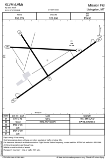


KLVM - Mission Fld
Located in Livingston, United States
ICAO - LVM, IATA - LVM
Data provided by AirmateGeneral information
Coordinates: N45°41'58" W110°26'53"
Elevation is 4659 feet MSL.
Magnetic variation is 15° East View others Airports in Montana
Operational data
Special qualification required
Current time UTC:
Current local time:
Weather
METAR: KLVM 081602Z AUTO 25015KT 1/2SM SN FG VV007 01/00 A2996 RMK AO2 P0000 T00110000
TAF: KLVM 081603Z 0816/0912 26015KT 2SM -SN BR SCT009 OVC015 TEMPO 0816/0818 3/4SM -SN BR OVC009 FM081800 27015KT 4SM -SHSNRA BR FEW009 OVC015 FM090000 29014KT 4SM -RA BR SCT009 BKN015 OVC025
Communications frequencies: [VIEW]
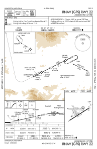
Runways:
| RWY identifier | QFU | Length (ft) | Width (ft) | Surface | LDA (ft) |
| 04 | 54° | 5701 | 75 | ASPH | |
| 22 | 234° | 5701 | 75 | ASPH | |
| 08 | 93° | 3762 | 125 | GRASS | |
| 26 | 273° | 3762 | 125 | GRASS | |
| 13 | 147° | 2724 | 120 | GRASS | |
| 31 | 327° | 2724 | 120 | GRASS |
Airport contact information
Address: Livingston United States