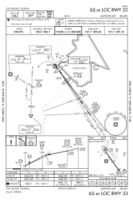
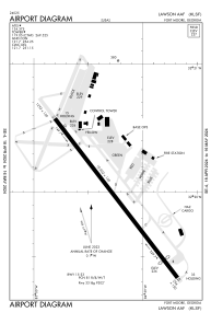


KLSF - Lawson Aaf (Fort Moore)
Located in Fort Moore (Columbus), United States
ICAO - LSF, IATA - LSF
Data provided by AirmateGeneral information
Coordinates: N32°19'54" W84°59'14"
Elevation is 227 feet MSL.
Magnetic variation is -05° East View others Airports in Georgia
Operational data
Special qualification required
Current time UTC:
Current local time:
Weather
TAF: TAF KLSF 172100Z 1721/1903 22007KT 4800 -RA BR SCT015 OVC030 540103 QNH2977INS TEMPO 1721/1800 23010G15KT 1200 -TSRA BKN005 OVC010CB BECMG 1800/1801 16003KT 3200 BR VCSH SCT003 BKN007 OVC012 540054 QNH2975INS TEMPO 1801/1804 9000 BR BKN020 BKN040 BECMG 1804/1805 18005KT 1600 -SHRA BR VCTS SCT003 BKN005CB OVC010 540053 QNH2976INS TEMPO 1807/1810 27010G15KT 0800 -TSRA FEW003 BKN005CB BECMG 1810/1811 23003KT 6000 -SHRA BR BKN007 OVC012 QNH2982INS BECMG 1816/1817 28007KT 9999 NSW SCT020 SCT040 BKN120 QNH2980INS BECMG 1822/1823 24005KT 9999 VCSH FEW025 BKN035 BKN085 QNH2981INS TEMPO 1901/1903 25010G15KT 9000 -SHRA VCTS BKN015CB OVC030 TX26/1821Z TN20/1811Z
Communications frequencies: [VIEW]
Runways:
| RWY identifier | QFU | Length (ft) | Width (ft) | Surface | LDA (ft) |
| 15 | 0° | 10002 | 150 | ASPH | 10002 |
| 33 | 0° | 10002 | 150 | ASPH | 9302 |
Airport contact information
Address: Fort Moore (Columbus) United States