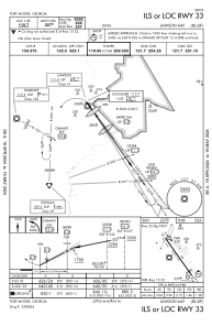
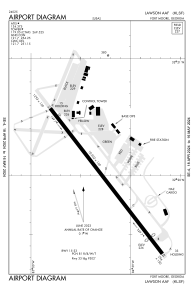


KLSF - Lawson Aaf (Fort Moore)
Located in Fort Moore (Columbus), United States
ICAO - LSF, IATA - LSF
Data provided by AirmateGeneral information
Coordinates: N32°19'54" W84°59'14"
Elevation is 227 feet MSL.
Magnetic variation is -05° East View others Airports in Georgia
Operational data
Special qualification required
Current time UTC:
Current local time:
Weather
METAR: KLSF 081135Z AUTO 00000KT 10SM OVC020 22/21 A2986 RMK AO2 SLP114 RVRNO VISNO RWY33 $
TAF: TAF AMD KLSF 081030Z 0810/0911 VRB05KT 9999 OVC012 QNH2982INS TEMPO 0810/0813 OVC007 BECMG 0813/0814 19008KT 9999 NSW SCT015 BKN030 QNH2975INS TEMPO 0818/0822 21012G18KT BECMG 0906/0907 20007KT 9999 BKN015 QNH2980INS TX32/0821Z TN20/0909Z
Communications frequencies: [VIEW]
Runways:
| RWY identifier | QFU | Length (ft) | Width (ft) | Surface | LDA (ft) |
| 15 | 0° | 10002 | 150 | ASPH | 10002 |
| 33 | 0° | 10002 | 150 | ASPH | 9302 |
Airport contact information
Address: Fort Moore (Columbus) United States