


KLND - Hunt Fld
Located in Lander, United States
ICAO - LND, IATA - LND
Data provided by AirmateGeneral information
Coordinates: N42°48'55" W108°43'43"
Elevation is 5588 feet MSL.
Magnetic variation is 10° East View others Airports in Wyoming
Operational data
Special qualification required
Current time UTC:
Current local time:
Weather
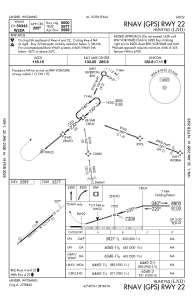
METAR: KLND 091902Z AUTO 07009KT 6SM -RA BKN027 BKN034 OVC050 06/02 A3030 RMK AO2 P0000 T00610017
TAF: KLND 091727Z 0918/1018 32006KT 6SM -RA SCT015 OVC025 TEMPO 0918/0922 P6SM SCT015 OVC040 FM092200 04006KT P6SM SCT025 BKN040 FM100300 33006KT P6SM SCT015 BKN035 FM100800 02005KT P6SM BKN015 OVC025 PROB30 1013/1017 6SM -RA OVC015
Communications frequencies: [VIEW]
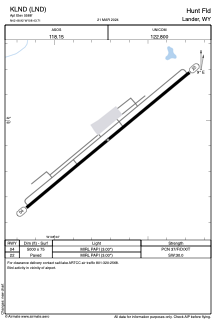
Runways:
| RWY identifier | QFU | Length (ft) | Width (ft) | Surface | LDA (ft) |
| 04 | 50° | 5000 | 75 | ASPH | |
| 22 | 230° | 5000 | 75 | ASPH |
Airport contact information
Address: Lander United States