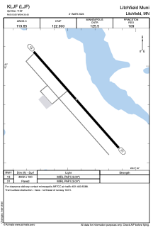


KLJF - Litchfield Muni
Located in Litchfield, United States
ICAO - LJF, IATA -
Data provided by AirmateGeneral information
Coordinates: N45°5'50" W94°30'26"
Elevation is 1139 feet MSL.
Magnetic variation is 02° East View others Airports in Minnesota
Operational data
Special qualification required
Current time UTC:
Current local time:
Weather
METAR: KLJF 091655Z AUTO 05011G19KT 10SM CLR 17/03 A2996 RMK AO2
Communications frequencies: [VIEW]
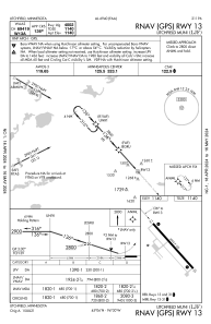
Runways:
| RWY identifier | QFU | Length (ft) | Width (ft) | Surface | LDA (ft) |
| 13 | 138° | 4002 | 100 | ASPH | |
| 31 | 318° | 4002 | 100 | ASPH |
Airport contact information
Address: Litchfield United States