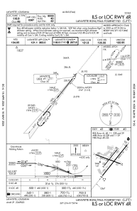
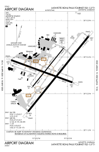


KLFT - Lafayette Rgnl/Paul Fournet Fld
Situé à Lafayette, United States
ICAO - LFT, IATA - LFT
Données fournies par AirmateInformation générale
Coordonnées: N30°12'18" W91°59'16"
Élévation : 41 feet MSL.
Variation magnétique : 03° East Voir autres Aéroports à Louisiana
Données opérationnelles
Special qualification required
Heure actuelle UTC:
Heure actuelle locale:
Météo
METAR: KLFT 171153Z VRB03KT 5SM BR OVC005 24/24 A2971 RMK AO2 LTG DSNT NE SLP059 60000 70127 T02440239 10244 20217 53016
TAF: KLFT 171138Z 1712/1812 VRB05KT P6SM VCSH OVC005 TEMPO 1712/1714 5SM BR FM171700 30007KT P6SM VCTS OVC012CB FM172100 35007KT P6SM VCTS SCT020CB OVC050 PROB30 1721/1803 4SM TSRA BKN015CB FM180300 VRB05KT P6SM VCTS SCT012CB BKN050 TEMPO 1805/1809 3SM TSRA OVC012CB
Fréquences de communication: [VIEW]
Pistes:
| Identifiant RWY | QFU | Longueur (ft) | Largeur (ft) | Surface | LDA (ft) |
| 04L | 39° | 4099 | 75 | ASPH | 4099 |
| 22R | 219° | 4099 | 75 | ASPH | 4099 |
| 04R | 39° | 8000 | 150 | ASPH | 8000 |
| 22L | 219° | 8000 | 150 | ASPH | 7659 |
| 11 | 110° | 5400 | 148 | ASPH | |
| 29 | 290° | 5400 | 148 | ASPH |
Coordonnées de l'aéroport
Adresse: Lafayette United States
Autres services d'aviation
Ateliers de réparation

Écoles de pilotage

Acadian Aviation Pilot Training Center
Acadian Aviation Pilot Training Center
raja@kaplantel.net+1(337)291-2884