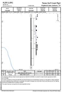


KLBX - Texas Gulf Coast Rgnl
Located in Angleton/Lake Jackson, United States
ICAO - LBX, IATA - LJN
Data provided by AirmateGeneral information
Coordinates: N29°6'31" W95°27'43"
Elevation is 25 feet MSL.
Magnetic variation is 05° East View others Airports in Texas
Operational data
Special qualification required
Current time UTC:
Current local time:
Weather
TAF: KLBX 091120Z 0912/1012 VRB03KT 4SM BR FEW008 OVC016 FM091600 14007KT P6SM SCT015 BKN025 FM092000 14008KT P6SM BKN030 FM100100 VRB04KT P6SM BKN015 FM100700 05005KT 5SM BR BKN010
Communications frequencies: [VIEW]
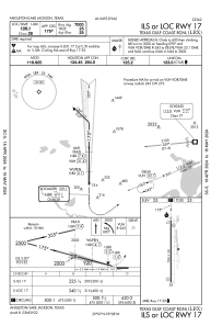
Runways:
| RWY identifier | QFU | Length (ft) | Width (ft) | Surface | LDA (ft) |
| 17 | 180° | 7000 | 100 | CONC | 7000 |
| 35 | 360° | 7000 | 100 | CONC | 7000 |
Airport contact information
Address: Angleton/Lake Jackson United States
Other aviation service providers
Flight schools

Coastal Planes Aviation, Llc
Coastal Planes Aviation, Llc
coastalplanesaviationllc@gmail.com+1(979)292-6971