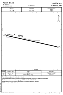


KLAM - Los Alamos
Located in Los Alamos, United States
ICAO - LAM, IATA - LAM
Data provided by AirmateGeneral information
Coordinates: N35°52'47" W106°16'7"
Elevation is 7170 feet MSL.
Magnetic variation is 10° East View others Airports in New Mexico
Operational data
Special qualification required
Current time UTC:
Current local time:
Weather
METAR: KLAM 081835Z AUTO 26017G25KT 220V300 6SM HZ CLR 14/M12 A2988 RMK AO2 PK WND 27037/1808 WSHFT 1755 T01391115 $
Communications frequencies: [VIEW]
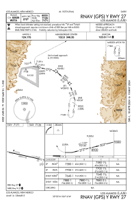
Runways:
| RWY identifier | QFU | Length (ft) | Width (ft) | Surface | LDA (ft) |
| 09 | 102° | 6000 | 120 | ASPH | |
| 27 | 282° | 6000 | 120 | ASPH |
Airport contact information
Address: Los Alamos United States