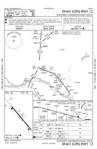
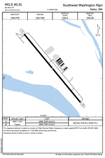


KKLS - Southwest Washington Rgnl
Located in Kelso, United States
ICAO - KLS, IATA - KLS
Data provided by AirmateGeneral information
Coordinates: N46°7'5" W122°53'54"
Elevation is 20 feet MSL.
Magnetic variation is 17° East View others Airports in Washington
Operational data
Special qualification required
Current time UTC:
Current local time:
Weather
METAR: KKLS 091856Z AUTO 33006KT 10SM CLR 21/09 A3028 RMK AO2 SLP257 T02060089
Communications frequencies: [VIEW]
Runways:
| RWY identifier | QFU | Length (ft) | Width (ft) | Surface | LDA (ft) |
| 12 | 140° | 4391 | 100 | ASPH | |
| 30 | 320° | 4391 | 100 | ASPH |
Airport contact information
Address: Kelso United States
