


KILM - Wilmington Intl
Located in Wilmington, United States
ICAO - ILM, IATA - ILM
Data provided by AirmateGeneral information
Coordinates: N34°16'16" W77°54'10"
Elevation is 31 feet MSL.
Magnetic variation is -10° East View others Airports in North Carolina
Operational data
Special qualification required
Current time UTC:
Current local time:
Weather
METAR: KILM 090023Z 29004KT 9SM VCTS -RA SCT100 BKN120 21/19 A2985 RMK AO2 LTG DSNT ALQDS P0002 T02110189
TAF: KILM 082322Z 0900/0924 22008KT 6SM TSRA BR BKN090CB FM090200 22006KT P6SM VCTS BKN200CB FM090400 22006KT 3SM BR SCT200 FM091200 23006KT 3SM BR BKN080 FM091300 23008KT P6SM SCT090
Communications frequencies: [VIEW]
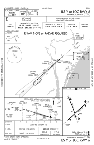
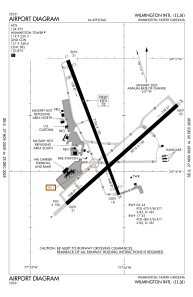
Runways:
| RWY identifier | QFU | Length (ft) | Width (ft) | Surface | LDA (ft) |
| 06 | 48° | 8016 | 150 | ASPH | 8016 |
| 24 | 228° | 8016 | 150 | ASPH | 8016 |
| 17 | 159° | 7754 | 150 | ASPH | 6604 |
| 35 | 339° | 7754 | 150 | ASPH | 7204 |
Airport contact information
Address: Wilmington United States