


KHYA - Cape Cod Gateway
Located in Hyannis, United States
ICAO - HYA, IATA - HYA
Data provided by AirmateGeneral information
Coordinates: N41°40'10" W70°16'49"
Elevation is 54 feet MSL.
Magnetic variation is -16° East View others Airports in Massachusetts
Operational data
Special qualification required
Current time UTC:
Current local time:
Weather
METAR: KHYA 090245Z AUTO VRB04G14KT 1/2SM FG VV002 12/12 A2960 RMK AO2 LTG DSNT S T01170117 RVRNO
TAF: KHYA 082320Z 0900/0924 22006KT 2SM -TSRA BKN005 OVC012CB FM090300 25005KT 1SM BR VCSH OVC003 FM091000 29006KT 4SM BR BKN015 FM091200 33007KT P6SM BKN040 FM091900 03011KT P6SM VCSH OVC020
Communications frequencies: [VIEW]
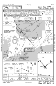
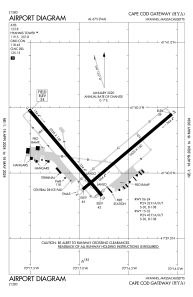
Runways:
| RWY identifier | QFU | Length (ft) | Width (ft) | Surface | LDA (ft) |
| 06 | 50° | 5425 | 150 | ASPH | 5019 |
| 24 | 230° | 5425 | 150 | ASPH | 5425 |
| 15 | 140° | 5255 | 150 | ASPH | 5255 |
| 33 | 320° | 5255 | 150 | ASPH | 5105 |
Airport contact information
Address: Hyannis United States
