


KHTS - Tri-State/Milton J Ferguson Fld
Located in Huntington, United States
ICAO - HTS, IATA - HTS
Data provided by AirmateGeneral information
Coordinates: N38°22'7" W82°33'37"
Elevation is 828 feet MSL.
Magnetic variation is -06° East View others Airports in West Virginia
Operational data
Special qualification required
Current time UTC:
Current local time:
Weather
METAR: KHTS 091351Z 07003KT 10SM BKN020 19/16 A2971 RMK AO2 SLP053 T01890161
TAF: KHTS 091258Z 0913/1012 19005KT P6SM BKN011 OVC018 TEMPO 0913/0917 21009G15KT SCT030 FM091700 25009G15KT P6SM VCSH BKN029 FM092000 26011G17KT P6SM VCTS SCT028 BKN035CB FM100200 29007KT P6SM BKN019 FM100500 29007KT 4SM BR BKN008
Communications frequencies: [VIEW]
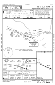
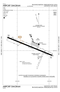
Runways:
| RWY identifier | QFU | Length (ft) | Width (ft) | Surface | LDA (ft) |
| 12 | 112° | 7017 | 150 | ASPH | 6516 |
| 30 | 292° | 7017 | 150 | ASPH | 6516 |
Airport contact information
Address: Huntington United States