


KHRU - Herington Rgnl
Located in Herington, United States
ICAO - HRU, IATA -
Data provided by AirmateGeneral information
Coordinates: N38°41'41" W96°48'29"
Elevation is 1480 feet MSL.
Magnetic variation is 06° East View others Airports in Kansas
Operational data
Special qualification required
Current time UTC:
Current local time:
Weather at : KFRI - Marshall Aaf ( 40 km )
METAR: KFRI 081955Z AUTO 30010G16KT 10SM CLR 25/04 A2958 RMK AO2 SLP008 T02540039 PNO $
TAF: TAF KFRI 082000Z 0820/1002 35010G20KT 9999 FEW250 QNH2957INS BECMG 0900/0901 33010KT 9999 FEW250 QNH2966INS TX26/0821Z TN10/0912Z
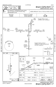
Communications frequencies: [VIEW]
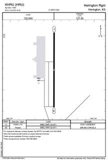
Runways:
| RWY identifier | QFU | Length (ft) | Width (ft) | Surface | LDA (ft) |
| 17 | 180° | 4184 | 75 | CONC | |
| 35 | 0° | 4184 | 75 | CONC |
Airport contact information
Address: Herington United States