


KHOU - William P Hobby
Located in Houston, United States
ICAO - HOU, IATA - HOU
Data provided by AirmateGeneral information
Coordinates: N29°38'45" W95°16'38"
Elevation is 46 feet MSL.
Magnetic variation is 03° East View others Airports in Texas
Operational data
Special qualification required
Current time UTC:
Current local time:
Weather
METAR: KHOU 091553Z 14009KT 4SM HZ BKN020 BKN200 29/24 A2972 RMK AO2 SLP070 T02940244
TAF: KHOU 091454Z 0915/1012 16007KT 4SM HZ FEW012 OVC025 FM091700 12008KT 6SM HZ BKN022 FM092100 13009KT 6SM HZ SCT025 BKN040 FM100200 14009KT P6SM VCTS BKN025CB FM100500 VRB03KT P6SM BKN020 FM101000 04006KT P6SM BKN015
Communications frequencies: [VIEW]
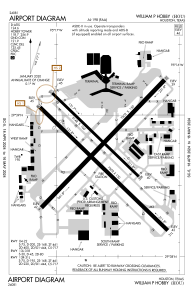
Runways:
| RWY identifier | QFU | Length (ft) | Width (ft) | Surface | LDA (ft) |
| 04 | 44° | 7602 | 150 | CONC | 7602 |
| 22 | 224° | 7602 | 150 | CONC | 7602 |
| 13L | 134° | 5148 | 100 | CONC | 5148 |
| 31R | 314° | 5148 | 100 | CONC | 5148 |
| 13R | 134° | 7602 | 150 | ASPH | 6568 |
| 31L | 314° | 7602 | 150 | ASPH | 7602 |
Airport contact information
Address: Houston United States
