


KHLN - Helena Rgnl
Located in Helena, United States
ICAO - HLN, IATA - HLN
Data provided by AirmateGeneral information
Coordinates: N46°36'24" W111°58'60"
Elevation is 3877 feet MSL.
Magnetic variation is 12° East View others Airports in Montana
Operational data
Special qualification required
Current time UTC:
Current local time:
Weather
METAR: KHLN 081353Z 27006KT 8SM UP OVC018 02/00 A3001 RMK AO2 RAE48UPB02E11B48 SLP196 P0006 T00170000
TAF: KHLN 081421Z 0814/0912 27008KT P6SM SCT015 BKN030 TEMPO 0814/0818 4SM -RA BR BKN015 FM081800 31012G20KT P6SM -RA SCT012 BKN020 FM082200 29008KT P6SM BKN015
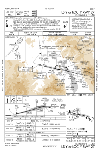
Communications frequencies: [VIEW]
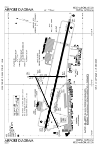
Runways:
| RWY identifier | QFU | Length (ft) | Width (ft) | Surface | LDA (ft) |
| 05 | 66° | 4644 | 75 | ASPH | 4644 |
| 23 | 246° | 4644 | 75 | ASPH | 4644 |
| 09 | 102° | 9000 | 150 | ASPH | 9000 |
| 27 | 282° | 9000 | 150 | ASPH | 9000 |
| 10 | 103° | 1584 | 75 | GRASS | |
| 28 | 283° | 1584 | 75 | GRASS | |
| 17 | 179° | 2989 | 75 | ASPH | 2989 |
| 35 | 359° | 2989 | 75 | ASPH | 2989 |
Airport contact information
Address: Helena United States
