


KGTB - Wheeler-Sack Aaf
Located in Fort Drum, United States
ICAO - GTB, IATA -
Data provided by AirmateGeneral information
Coordinates: N44°3'20" W75°43'12"
Elevation is 689 feet MSL.
Magnetic variation is -13° East View others Airports in New York
Operational data
Special qualification required
Current time UTC:
Current local time:
Weather
METAR: KGTB 082255Z AUTO 02005KT 10SM BKN006 OVC010 10/09 A2961 RMK AO2 RAE35DZB35E39 CIG 005 RWY03 SLP028 P0003 T00990085
TAF: TAF AMD KGTB 082134Z 0821/0923 25015G20KT 9000 -SHRA BKN005 OVC022 530004 QNH2951INS TEMPO 0821/0822 26015G25KT 6000 -TSRA OVC003CB BECMG 0822/0823 VRB06KT 9999 VCSH BKN007 OVC014 QNH2956INS BECMG 0823/0824 VRB06KT 9999 NSW OVC004 QNH2960INS BECMG 0907/0908 VRB06KT 6000 BR SCT001 OVC008 QNH2969INS BECMG 0914/0915 05012KT 9999 NSW FEW009 OVC016 QNH2978INS BECMG 0917/0918 03010G15KT 9999 FEW024 SCT035 BKN055 QNH2975INS TX13/0821Z TN07/0910Z
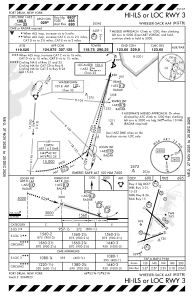
Communications frequencies: [VIEW]
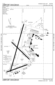
Runways:
| RWY identifier | QFU | Length (ft) | Width (ft) | Surface | LDA (ft) |
| 03 | 0° | 10000 | 150 | CONC | |
| 21 | 0° | 10000 | 150 | CONC | |
| 08 | 0° | 4501 | 150 | OTHER | |
| 26 | 0° | 4501 | 150 | OTHER | |
| 15 | 0° | 5002 | 144 | CONC | |
| 33 | 0° | 5002 | 144 | CONC |
Airport contact information
Address: Fort Drum United States