


KGRF - Gray Aaf (Joint Base Lewis-Mcchord)
Located in Fort Lewis/Tacoma, United States
ICAO - GRF, IATA - GRF
Data provided by AirmateGeneral information
Coordinates: N47°4'45" W122°34'51"
Elevation is 301 feet MSL.
Magnetic variation is 16° East View others Airports in Washington
Operational data
Special qualification required
Current time UTC:
Current local time:
Weather
METAR: KGRF 091155Z 12004KT 10SM CLR 05/02 A3034 RMK AO2A SLP278 T00450020 10123 20039 58000 $
TAF: TAF KGRF 090500Z 0905/1011 15003KT 9999 SKC QNH3035INS BECMG 0916/0917 22010G15KT 9999 SKC 510003 QNH3035INS BECMG 1004/1005 15006KT 9999 SKC QNH3021INS TX23/0923Z TN06/0912Z
Communications frequencies: [VIEW]
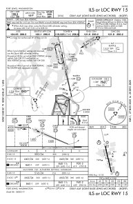
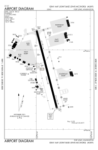
Runways:
| RWY identifier | QFU | Length (ft) | Width (ft) | Surface | LDA (ft) |
| 15 | 167° | 6124 | 150 | ASPH | |
| 33 | 347° | 6124 | 150 | ASPH | |
| H2 | 0° | 0 | 0 | UNK | |
| H3 | 0° | 0 | 0 | UNK | |
| H4 | 0° | 0 | 0 | UNK |
Airport contact information
Address: Fort Lewis/Tacoma United States