


KGJT - Grand Junction Rgnl
Located in Grand Junction, United States
ICAO - GJT, IATA - GJT
Data provided by AirmateGeneral information
Coordinates: N39°7'21" W108°31'36"
Elevation is 4861 feet MSL.
Magnetic variation is 13° East View others Airports in Colorado
Operational data
Special qualification required
Current time UTC:
Current local time:
Weather
METAR: KGJT 082253Z 00000KT 8SM BKN085 14/M09 A2991 RMK AO2 SLP110 T01441089
TAF: KGJT 081720Z 0818/0918 33008KT P6SM FEW120 FM090200 03008KT P6SM FEW090 SCT200 FM090700 05004KT P6SM FEW080 SCT140
Communications frequencies: [VIEW]
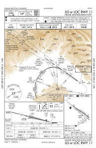
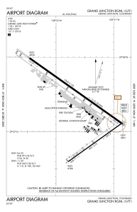
Runways:
| RWY identifier | QFU | Length (ft) | Width (ft) | Surface | LDA (ft) |
| 04 | 54° | 5501 | 75 | ASPH | 5501 |
| 22 | 234° | 5501 | 75 | ASPH | 5501 |
| 11 | 125° | 10503 | 150 | ASPH | 10503 |
| 29 | 305° | 10503 | 150 | ASPH | 10503 |
Airport contact information
Address: Grand Junction United States

