


KGFL - Floyd Bennett Meml
Located in Glens Falls, United States
ICAO - GFL, IATA - GFL
Data provided by AirmateGeneral information
Coordinates: N43°20'28" W73°36'37"
Elevation is 328 feet MSL.
Magnetic variation is -14° East View others Airports in New York
Operational data
Special qualification required
Current time UTC:
Current local time:
Weather
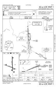
METAR: KGFL 082153Z AUTO VRB04KT 10SM FEW085 FEW110 21/09 A2949 RMK AO2 PK WND 31032/2131 RAB32E44 SLP986 P0000 T02110094
TAF: KGFL 082228Z 0822/0918 28005KT P6SM -SHRA SCT015 BKN035 FM090000 27009KT P6SM VCSH BKN040 FM090400 32005KT P6SM OVC025 FM090800 35007KT P6SM OVC015 FM091600 02007KT P6SM OVC035
Communications frequencies: [VIEW]
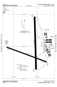
Runways:
| RWY identifier | QFU | Length (ft) | Width (ft) | Surface | LDA (ft) |
| 01 | 358° | 5000 | 150 | ASPH | 5000 |
| 19 | 178° | 5000 | 150 | ASPH | 5000 |
| 12 | 110° | 3999 | 100 | ASPH | 3999 |
| 30 | 290° | 3999 | 100 | ASPH | 3999 |
Airport contact information
Address: Glens Falls United States
