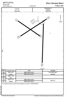


KFTT - Elton Hensley Meml
Located in Fulton, United States
ICAO - FTT, IATA -
Data provided by AirmateGeneral information
Coordinates: N38°50'17" W92°0'9"
Elevation is 886 feet MSL.
Magnetic variation is 01° East View others Airports in Missouri
Operational data
Special qualification required
Current time UTC:
Current local time:
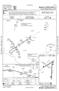
Communications frequencies: [VIEW]
Runways:
| RWY identifier | QFU | Length (ft) | Width (ft) | Surface | LDA (ft) |
| 06 | 57° | 3203 | 60 | CONC | |
| 24 | 237° | 3203 | 60 | CONC | |
| 12 | 124° | 2488 | 100 | GRASS | |
| 30 | 304° | 2488 | 100 | GRASS | |
| 18 | 181° | 4001 | 75 | CONC | |
| 36 | 1° | 4001 | 75 | CONC |
Airport contact information
Address: Fulton United States