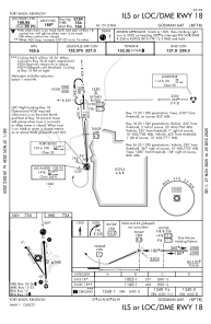
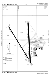


KFTK - Godman Aaf
Located in Fort Knox, United States
ICAO - FTK, IATA - FTK
Data provided by AirmateGeneral information
Coordinates: N37°54'25" W85°58'19"
Elevation is 754 feet MSL.
Magnetic variation is -03° East View others Airports in Kentucky
Operational data
Special qualification required
Current time UTC:
Current local time:
Weather
METAR: KFTK 082255Z AUTO 12008KT 10SM -RA OVC060 20/19 A2969 RMK AO2 LTG DSNT NE AND SE AND NW TSB2159E18TSB28E46 SLP052 P0010 T02010187
TAF: TAF KFTK 081900Z 0819/1001 16009KT 9999 FEW015 BKN100 BKN250 QNH2967INS BECMG 0820/0821 14009KT 8000 -RA VCTS BKN020CB OVC250 QNH2959INS TEMPO 0821/0903 26015G25KT 4800 TSRA OVC010CB BECMG 0902/0903 15009KT 8000 -RA VCTS BKN012CB OVC030 QNH2950INS TEMPO 0903/0906 26015G25KT 3200 TSRA OVC008CB BECMG 0908/0909 20009KT 9999 NSW BKN010 OVC100 QNH2953INS BECMG 0913/0914 24012G20KT 9999 BKN015 OVC250 510005 QNH2962INS BECMG 0922/0923 26009KT 9999 SCT020 BKN050 BKN200 QNH2970INS TX27/0820Z TN17/0911Z LAST NO AMDS AFT 0903 NEXT 0911
Communications frequencies: [VIEW]
Runways:
| RWY identifier | QFU | Length (ft) | Width (ft) | Surface | LDA (ft) |
| 15 | 0° | 4853 | 75 | ASPH | |
| 33 | 0° | 4853 | 75 | ASPH | |
| 18 | 0° | 5184 | 150 | ASPH | |
| 36 | 0° | 5184 | 150 | ASPH |
Airport contact information
Address: Fort Knox United States