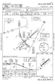
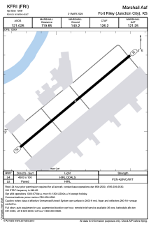


KFRI - Marshall Aaf
Located in Fort Riley (Junction City), United States
ICAO - FRI, IATA - FRI
Data provided by AirmateGeneral information
Coordinates: N39°3'10" W96°45'52"
Elevation is 1066 feet MSL.
Magnetic variation is 06° East View others Airports in Kansas
Operational data
Special qualification required
Current time UTC:
Current local time:
Weather
METAR: KFRI 080355Z AUTO 00000KT 10SM OVC100 17/09 A2957 RMK AO2 SLP007 T01700087 PNO $
TAF: TAF KFRI 080400Z 0804/0910 12004KT 9999 BKN140 QNH2954INS TEMPO 0804/0806 8000 -SHRA BKN120 BECMG 0806/0807 VRB06KT 9999 FEW250 QNH2954INS BECMG 0815/0816 32010G20KT 9999 FEW250 QNH2958INS BECMG 0823/0824 31009KT 9999 FEW250 QNH2965INS TX24/0820Z TN12/0810Z
Communications frequencies: [VIEW]
Runways:
| RWY identifier | QFU | Length (ft) | Width (ft) | Surface | LDA (ft) |
| 04 | 50° | 4503 | 100 | CONC | |
| 22 | 230° | 4503 | 100 | CONC |
Airport contact information
Address: Fort Riley (Junction City) United States