


KFMH - Cape Cod Coast Guard Air Station
Located in Falmouth, United States
ICAO - FMH, IATA - FMH
Data provided by AirmateGeneral information
Coordinates: N41°39'33" W70°31'22"
Elevation is 130 feet MSL.
Magnetic variation is -15° East View others Airports in Massachusetts
Operational data
Special qualification required
Current time UTC:
Current local time:
Weather
METAR: KFMH 090745Z 31007KT 10SM CLR 10/10 A2962
TAF: KFMH 090531Z 0906/1006 00000KT 3SM BR OVC003 FM090900 30004KT 1/2SM FG OVC003 FM091200 33008KT P6SM BKN020 FM091700 02010KT P6SM BKN045 FM092300 05008KT P6SM OVC025
Communications frequencies: [VIEW]
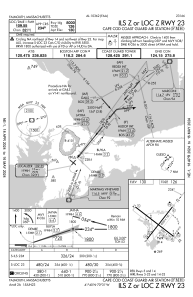
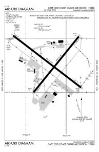
Runways:
| RWY identifier | QFU | Length (ft) | Width (ft) | Surface | LDA (ft) |
| 05 | 39° | 8000 | 150 | OTHER | |
| 23 | 219° | 8000 | 150 | OTHER | |
| 14 | 127° | 9501 | 150 | OTHER | |
| 32 | 307° | 9501 | 150 | OTHER |
Airport contact information
Address: Falmouth United States