


KEUG - Mahlon Sweet Fld
Located in Eugene, United States
ICAO - EUG, IATA - EUG
Data provided by AirmateGeneral information
Coordinates: N44°7'28" W123°12'43"
Elevation is 373 feet MSL.
Magnetic variation is 15° East View others Airports in Oregon
Operational data
Special qualification required
Current time UTC:
Current local time:
Weather
METAR: KEUG 082154Z 30012G18KT 10SM FEW035 17/07 A3033 RMK AO2 SLP271 T01720067 $
Communications frequencies: [VIEW]
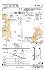
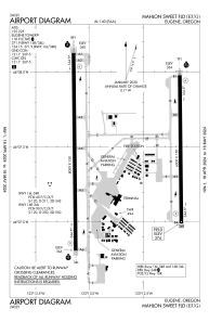
Runways:
| RWY identifier | QFU | Length (ft) | Width (ft) | Surface | LDA (ft) |
| 16L | 179° | 6000 | 150 | ASPH | 6000 |
| 34R | 359° | 6000 | 150 | ASPH | 6000 |
| 16R | 179° | 8009 | 150 | ASPH | 8009 |
| 34L | 359° | 8009 | 150 | ASPH | 8009 |
Airport contact information
Address: Eugene United States