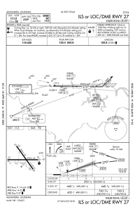
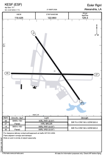


KESF - Esler Rgnl
Located in Alexandria, United States
ICAO - ESF, IATA - ESF
Data provided by AirmateGeneral information
Coordinates: N31°23'42" W92°17'45"
Elevation is 111 feet MSL.
Magnetic variation is 01° East View others Airports in Louisiana
Operational data
Special qualification required
Current time UTC:
Current local time:
Weather
METAR: KESF 091653Z AUTO 30004KT 3SM HZ FEW019 BKN033 OVC042 28/24 A2980 RMK AO2 SLP090 T02830244
Communications frequencies: [VIEW]
Runways:
| RWY identifier | QFU | Length (ft) | Width (ft) | Surface | LDA (ft) |
| 09 | 91° | 5998 | 150 | ASPH | |
| 27 | 271° | 5998 | 150 | ASPH | |
| 14 | 145° | 5600 | 150 | ASPH | |
| 32 | 325° | 5600 | 150 | ASPH |
Airport contact information
Address: Alexandria United States