


KELM - Elmira/Corning Rgnl
Located in Elmira/Corning, United States
ICAO - ELM, IATA - ELM
Data provided by AirmateGeneral information
Coordinates: N42°9'35" W76°53'30"
Elevation is 955 feet MSL.
Magnetic variation is -12° East View others Airports in New York
Operational data
Special qualification required
Current time UTC:
Current local time:
Weather
METAR: KELM 080353Z AUTO 00000KT 10SM CLR 16/08 A2968 RMK AO2 SLP046 T01560078
TAF: KELM 072320Z 0800/0824 VRB03KT P6SM FEW250 FM080600 15006KT P6SM OVC050 FM080700 18006KT 4SM -SHRA BR OVC030 TEMPO 0807/0810 2SM +SHRA BKN010 FM081100 22009G14KT P6SM OVC020 FM081300 26013G19KT P6SM SCT040
Communications frequencies: [VIEW]
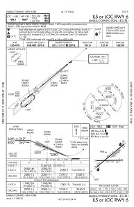
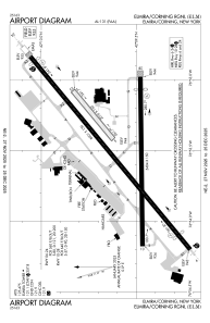
Runways:
| RWY identifier | QFU | Length (ft) | Width (ft) | Surface | LDA (ft) |
| 05 | 50° | 2016 | 150 | GRASS | 2017 |
| 23 | 230° | 2016 | 150 | GRASS | 2017 |
| 06 | 50° | 8001 | 150 | ASPH | 7401 |
| 24 | 230° | 8001 | 150 | ASPH | 7799 |
| 10 | 89° | 5404 | 150 | ASPH | 5004 |
| 28 | 269° | 5404 | 150 | ASPH | 5002 |
Airport contact information
Address: Elmira/Corning United States