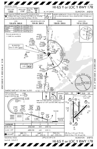
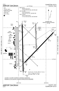


KEFD - Ellington
Located in Houston, United States
ICAO - EFD, IATA - EFD
Data provided by AirmateGeneral information
Coordinates: N29°36'26" W95°9'32"
Elevation is 32 feet MSL.
Magnetic variation is 05° East View others Airports in Texas
Operational data
Special qualification required
Current time UTC:
Current local time:
Weather
METAR: KEFD 091715Z 13005KT 2 1/2SM TS HZ SCT020CB BKN026 29/25 A2974
TAF: TAF AMD KEFD 091741Z 0917/1018 15012KT 4800 TSRA BKN020CB OVC060 QNH2960INS TEMPO 0917/0920 3200 BR BKN010 BECMG 1003/1004 14008KT 9000 BR SCT010 BKN025 QNH2965INS TEMPO 1004/1010 13004KT 4800 BR BKN010 BECMG 1016/1017 04012KT 8000 BR OVC010 QNH2989INS TX31/0919Z TN24/1008Z
Communications frequencies: [VIEW]
Runways:
| RWY identifier | QFU | Length (ft) | Width (ft) | Surface | LDA (ft) |
| 04 | 44° | 8001 | 150 | CONC | 8001 |
| 22 | 224° | 8001 | 150 | CONC | 8001 |
| 17L | 179° | 4609 | 75 | CONC | 4609 |
| 35R | 359° | 4609 | 75 | CONC | 4609 |
| 17R | 179° | 9001 | 150 | CONC | 9001 |
| 35L | 359° | 9001 | 150 | CONC | 9001 |
Airport contact information
Address: Houston United States
