


KEAU - Chippewa Valley Rgnl
Located in Eau Claire, United States
ICAO - EAU, IATA - EAU
Data provided by AirmateGeneral information
Coordinates: N44°51'57" W91°29'3"
Elevation is 913 feet MSL.
Magnetic variation is 01° East View others Airports in Wisconsin
Operational data
Special qualification required
Current time UTC:
Current local time:
Weather
METAR: KEAU 091056Z 03004KT 10SM CLR 11/08 A2983 RMK AO2 SLP100 T01060078
TAF: KEAU 091120Z 0912/1012 05008KT P6SM BKN040 FM092100 36007KT P6SM SCT060 FM100200 36002KT P6SM SKC
Communications frequencies: [VIEW]
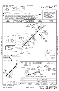
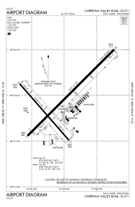
Runways:
| RWY identifier | QFU | Length (ft) | Width (ft) | Surface | LDA (ft) |
| 04 | 45° | 8101 | 150 | CONC | 7701 |
| 22 | 225° | 8101 | 150 | CONC | 7301 |
| 14 | 139° | 5000 | 100 | OTHER | 5000 |
| 32 | 319° | 5000 | 100 | OTHER | 5000 |
Airport contact information
Address: Eau Claire United States
