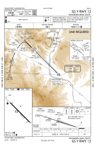
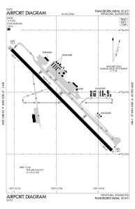


KEAT - Pangborn Meml
Located in Wenatchee, United States
ICAO - EAT, IATA - EAT
Data provided by AirmateGeneral information
Coordinates: N47°23'56" W120°12'25"
Elevation is 1248 feet MSL.
Magnetic variation is 15° East View others Airports in Washington
Operational data
Special qualification required
Current time UTC:
Current local time:
Weather
METAR: KEAT 090955Z AUTO 32012KT 10SM CLR 12/04 A3033 RMK AO2 SLP268 T01220044 $
TAF: KEAT 090520Z 0906/1006 30007KT P6SM SKC FM092000 12006KT P6SM SKC FM100400 31006KT P6SM SKC
Communications frequencies: [VIEW]
Runways:
| RWY identifier | QFU | Length (ft) | Width (ft) | Surface | LDA (ft) |
| 12 | 135° | 7000 | 150 | ASPH | 7000 |
| 30 | 315° | 7000 | 150 | ASPH | 7000 |
Airport contact information
Address: Wenatchee United States
