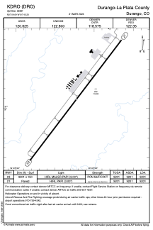


KDRO - Durango-La Plata County
Located in Durango, United States
ICAO - DRO, IATA - DRO
Data provided by AirmateGeneral information
Coordinates: N37°9'6" W107°45'14"
Elevation is 6689 feet MSL.
Magnetic variation is 10° East View others Airports in Colorado
Operational data
Special qualification required
Current time UTC:
Current local time:
Weather
TAF: KDRO 081720Z 0818/0918 26012G18KT P6SM SKC FM082300 26018G28KT P6SM SKC FM090200 26012KT P6SM SKC FM090600 04005KT P6SM SKC
Communications frequencies: [VIEW]
Runways:
| RWY identifier | QFU | Length (ft) | Width (ft) | Surface | LDA (ft) |
| 03 | 37° | 9201 | 150 | ASPH | 9201 |
| 21 | 217° | 9201 | 150 | ASPH | 9201 |
Airport contact information
Address: Durango United States