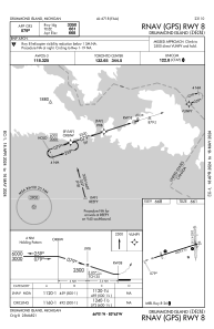


KDRM - Drummond Island
Located in Drummond Island, United States
ICAO - DRM, IATA - DRE
Data provided by AirmateGeneral information
Coordinates: N46°0'34" W83°44'38"
Elevation is 668 feet MSL.
Magnetic variation is -07° East View others Airports in Michigan
Operational data
Special qualification required
Current time UTC:
Current local time:
Weather
METAR: KDRM 080355Z AUTO 28004KT 3SM -RA SCT034 BKN042 OVC080 09/09 A2965 RMK AO2 P0037 T00930091
Communications frequencies: [VIEW]
Runways:
| RWY identifier | QFU | Length (ft) | Width (ft) | Surface | LDA (ft) |
| 01 | 358° | 2500 | 150 | OTHER | |
| 19 | 178° | 2500 | 150 | OTHER | |
| 08 | 72° | 4000 | 75 | ASPH | |
| 26 | 252° | 4000 | 75 | ASPH |
Airport contact information
Address: Drummond Island United States